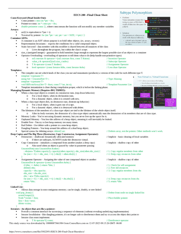
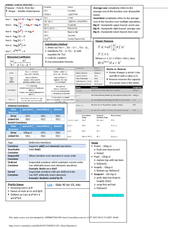
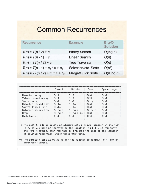
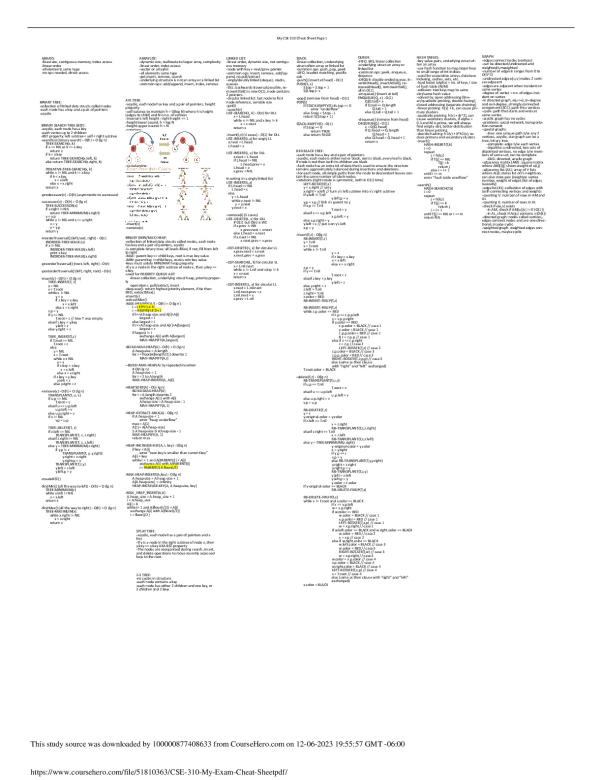
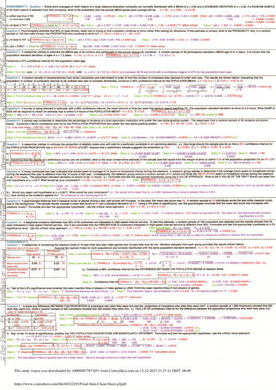
University of British Columbia
ATSC 113
R =Visual Flight Rules = fly by mostly looking out the window. You need good visibility and need to stay out of clouds | IFR = Instrument Flight Rules: Navigate using GPS, instruments, relying on air traffic control (ATC), requires a filed flight plan | billow (K-H Wave) = indicate CAT and wind shear, look like waves �|Castellanus= ca
...[Show More]
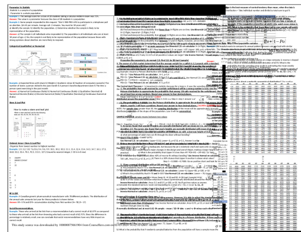
R =Visual Flight Rules = fly by mostly looking out the window. You need good visibility and need to stay out of clouds | IFR = Instrument Flight Rules: Navigate using GPS, instruments, relying on air traffic control (ATC), requires a filed flight plan | billow (K-H Wave) = indicate CAT and wind shear, look like waves �|Castellanus= castle turret like clouds, these & KH wave are a sign of unstable air |Rotor Clouds= Indicate extreme and severe turbulence at low altitudes due to mountain waves (break wings, danger high, look like a UFO dome) | Lenticular clouds= vertical wave wind oscillation & possible mountain wake turbulence, bumpy ride for commercial aircrafts | Banner cloud= Form on downwind side of mountain peak. Indicate strong turbulence touching the downwind side of a tall, isolated mountain peak.| Pyrocumlus – form over forest fires and volcanoes| Pileus – fast growing cumulus, harmless.| Fractus - turbulent humid air near the ground, indicate high humidity | Human made clouds = Fumulus (towers) & Contrails | Four ways cloud ceilings are measured: Laser ceilometers, ceiling balloons, pilot reports, weather-observer estimates | METAR=Meteorological Aviation Reports | Higher altitude=pressure and density smoothly decreases |Hypoxic= goofiness from insufficient oxygen supply | Armstrong limit= altitude above which bodily fluids boil at normal body temperature. Above 62,000 ft / 19km| Density(ρ) = mass/Volume | Pressure altitude= altitude measured from atmospheric pressure alone | Density altitude= altitude that the aircraft “feels” | Crosswinds = winds coming from the sides | Headwinds = winds coming directly towards you, slowing you down | Tailwinds = winds directly behind you | Wind Components are calculated by using the components of headwind/crosswinds (see chart on next page)| Wind Shear= A change of wind speed and or wind direction with altitude | Sea breeze= colder air blowing onshore from the sea, typically during the day, Land breeze= night | Anabatic winds= warm air moving up along mountain slopes that are warmed by the sun during daytime. Can form anabatic cumulus clouds | Katabatic winds= cold air draining down mountain slopes into valleys at nighttime as the mountain slopes cools. | Mountain wave= air oscillating up and down after it hits a mountain. Downdrafts are stronger than updrafts on the resulting waves | Thermals= Sunlight heats the ground, heating up the air it touches, this warm air rises as thermals | Convective boundary air= is the air that is considered in the thermal, can be 1-4km by mid afternoon |Cloud streets/Horizontal roll vortices= rows of clouds, parallel to each other, product of cold-air advection & temp inversion | Valley wind= long wind blowing very gently upstream during daytime | Standard atmosphere= avg. variation of air pressure (P), temperature (T), and density (ρ) with altitude (see the spheres chart on back page, all of our weather happens in the troposphere) | CAPE index= thunderstorm index, the higher cape the more intense storm, 1750 is an ordinary thunderstorm and max thunderstorm is at 2850 | K index= rain intensity in thunderstorm 20-40 | Turbulence= the random gusty fluctuations (vertical and horizontal) of wind | Types of turbulence: Convective/free convection/thermal turbulence= due to buoyancy, warm air rising and cold air sinking. Wind-shear/forced/mechanical turbulence= different wind speeds or directions at different altitudes | Obstacle turbulence= caused by wind hitting an object and flowing around it | Wake turbulence= trail left behind by an aircraft as it flies | Froude number = small # means light winds and stable conditions, Fr # = 1 is most violent fluctuations, Fr infinity means lots of turbulent wakes behind the mountain aka chop (see image in back page) | Eddies = swirls of air motion | CAT= clear air turbulence, wind shear turbulence outside a cloud | Boundary layer turbulence caused by layers of the planets boundaries, is often weak to moderate, but enough to make passengers sick | Supercooled water/droplets= liquid water cloud/rain well below the freezing point, but freezes on aircraft/objects immediately upon impact | Two types of Ice on a plane= Clear ice (freezes a little slower roughly a sec but stronger and harder to remove) and Rime ice (white weak instant freezing ice easy to remove) | Modern planes have deicing or anti-icing systems within the planes, meaning that commercial planes shouldn’t really have issues |Front Types = If the cold air advances, it is a cold front. If the cold air retreats, it is a warm front. If the boundary doesn't move very much, it is a stationary front. | Occluded front= if a cold front catches up and merges with a warm front. See image on back side.| Isotherms are closer together in a warm and cold front and a close in an occluded front (but not as close/strong) than they normally are | Dry line= boundary between dry and humid air at roughly the same temperature. Squall line = band of thunderstorms associated with a cold front. Thunderstorms = Convective clouds, 3 types; basic, mesoscale convective systems and supercells | Thunderstorm Stages = 1) Cumulus: Updrafts, no downdrafts. No rain. No anvil 2) Mature: Both up and downdrafts. Rain. Anvil. Most violent stage 3) Dissipating: Downdrafts, no updrafts. Raining itself out, leaving ice crystals in the middle and upper parts of the cloud. Not very visible on radar | Downbursts= rapid descending downbursts of air, smaller ones are called microbursts. Downburst winds can be harmful to structures and they create outflow winds which could result in arc clouds or haboobs (sand storms)| Graupel= hail that has a smaller diameter of 0.5 cm | Hail is classified on the TORRO index ranging from 1-10 and is extremely dangerous to aircrafts. (0 = pea, 6 = egg, 10 = melon) | Tornados are violently rotating columns of air between thunderstorm clouds and ground, most powerful one is supercell, measured on the Enhanced Fujita scale (EF) from 0 to 5 | TAF Terminal Aerodrome forecasts = future wind forecasts | SPECI as special report if METAR is not accurate to sudden weather change | Warm occlusion has cold coming close to warm, but warm still dominant. Cold occlusion has cold coming on to warm and cold is dominant | Unstable air is when you have warm air under cold air and that creates turbulence, cold air wants to sink and warm wants to go up. A thunderstorm results when the air mixes | Static stability: see image of equation on back side, corresponds to the calculated S value: Negative = statically unstable--air becomes turbulent, Zero = statically neutral—air is neutral (not turbulent nor non-turbulent), Positive = statically stable —air becomes non-turbulent| Low Pressure System Direction - Clockwise in southern hemisphere and Counter-clockwise in northern hemisphere. Directions are reversed for high pressure systems. Skiing: Pressure level map: black contours show lines of constant temperature, new line every Δ2°C. Pressure is used as a vertical coordinate much like meters: 100kPa = 0m, 95kPa = 500m, 90kPa = 1000m, 85kPa = 1500m, 80kPa = 2000m, 70kPa = 3000m, 62.5kPa = 4000m | NWP (Numerical Weather Prediction) is the analytical map that becomes the forecast map. These are merely predictions | Wind Barbs= see symbols chart on back page for corresponding values Convert m/s to km/h multiply by 4, or multiply knots by 2 | Relative Humidity (RH) = how much pressure that’s actually in the air to how much the air is able to hold. RH under 50% then no clouds, RH =70% means we start seeing cloud formations, RH = 90% then overcast cloud cover, if greater then may have little to no visibility!| If there is an unbroken “overcast” cloud layer under you then it is an undercast. | Condensation begins to appear when RH reaches 100% | Low pressure systems/cyclones = bad weather, can include heavy precipitation, strong winds and low visibility, not good to ski in. | Green on a kPa map indicates humidity and lots of clouds | Isobars show various pressure variations, when close together, suggest a cold/warm front incoming or occluded front | Low pressure troughs are marked with dashed lines, High pressure troughs with squiggly lines | High pressure is highest point (ridges) when isobars are increasing in pressure and low pressure is lowest point (troughs) when they are decreasing in pressure | Wind converges towards the center of the low, in northern hemisphere the Coriolis effect turns these winds to the right and so the air turns counter clockwise around a cyclone, opposite to a high pressure system | High pressure/anticyclone is when pressure is higher than surrounding regions, typically better more sunny less wind, more safe for skiing, lack of precipitation weather. Sometimes if low-pressure is incoming strong winds could be present | SLP= Sea level Pressure | Insolation= incoming solar radiation – visual light and ultraviolet (UV) radiation | Snow reflects 90% of light meaning that you get hit by Insolation twice, you would get sun burned | With approaching low pressure increasing high clouds can lead to flat light, clouds diffuse the light (when you can’t see bumps in the snow anymore). | Frontal zone= relative strong horizontal temperature gradient | Isobars are for pressure shown as full lines, Isotherms are for temperature shown as dashed lines | Frontal zone Indication are wind shift, pressure trough and higher relative humidity| In BC winds in front of cold front winds typically come from south-easterly to south and winds after a cold front typically come from north/north-westerly or south-westerly | Cold fronts indicate the boundary between relatively warmer and colder air masses, where the cold air is advancing | Long cold fronts and cold temperatures can lead to Hypothermia and frostbite | Wind chill is not the actual temp but rather the apparent temp/how cold it feels due to combined effect of wind and temp | As cold fronts approach then they can mix with warm fronts and create cumulonimbus with some precipitation cloud | Blowing snow, Heavy snowfall, clouds and fog cause less visibility (horizontal and vertical) | Convective showers are possible because air mass is typically unstable | Warm front = boundary between warm and cold air masses and the warm front is advancing | In the Northern Hemisphere midlatitudes, the winds ahead of a warm front typically come from an easterly direction. Behind the front, winds shift to be more southerly | Whiteout conditions= impossible to see anything |Behind warm front some convective clouds, showers are possible due to weak instabilities on air masses | Typically weak pressure gradient (a change of pressure across a horizontal distance) indicates light winds | 3 types of satellite imagery: visible (light gray image of clouds and earth, but can only see during daytime -> nighttime blindspot), infrared (IR) (shows radiation emitted, i.e. how hot/cold an object is) and water vapor (shows water vapor and not moisture) | Geostationary satellites match the rotation of the earth and can take loads of pictures from one place, but hard to see smaller features | Polar-orbiting (orbit on poles at low altitude) satellites can view small weather features and clouds but can’t always see the same area | Katabatic (drainage flow) winds lead to cold air pooling [can strengthen an already existing temperature inversion (higher altitude=higher temp)] these winds are typically created during night-time as the ground loses its heat source and starts to cool | Diurnal slope flow is created by thermal temp changes over the course of a day, as a result of the sun heating the earth’s surface (in turn heating up the air above it as well = relative heating) and then the earth’s surface cooling after the sun sets (which in turn cools the air) [radiative cooling]. This cycle happens during high-pressure system | As shallow layer of cold air moves downslope, it converges into small valleys, as these valleys become larger and eventually becomes a valley cold pool of air | Adiabatic lapse rate= change of temp with altitude | If a temp inversion traps moisture then it can create a valley cloud (when moisture condenses within the air in a valley) and rising air doesn’t travel higher, thus it’s a Capping Inversion | Inversions occur due to: subsidence (sinking motion) due to high pressure, and radiative cooling of the ground. | Clouds dissipate from the bottom up | Freezing fog= valley fog that occurs at temp below 0 resulting in supercooled droplets and rime ice |(orography = study of mountains)--orographic uplift= when air lifts over mountains, as air lifts it cools down adiabatically [Δ10°C/km (dry) and Δ6°/km (wet)] | Dewpoint= air temp at which water vapour
[Show Less]
-preview.png)
-preview.png)